The Original Pocahontas
Trail Overview
The Original Pocahontas trail, named to honor the famous coal heritage of the town and surrounding region has over 70 miles on 2100 acres with 10 miles of that being Single Track. The trail has a lot of scenic twists and turns with spectacular views and a lot of places to stop and enjoy the dense lush woods. The OP trail provides visitors with an exciting “deep woods” experience along with relaxing rest stops and stunning vistas. It’s a trail that you can spend the whole day exploring but you will keep coming back for more.
- Located in Tazewell County
- 94 miles over 1,800 acres
- 1o miles Single Track
- 46% Green, 45% Blue, 5% Black, 0% Yellow
Trailhead Coordinates:
- Pocahontas: 37.30517717638337, -81.34232274256647
- Boissevain: 37.28950727240917, -81.37182704173028
Trailhead Addresses:
- Pocahontas: 210 Railroad Ally, Pocahontas, VA 24635
- Boissevain: 132 Miners Park Lane, Bluefield, VA 24605
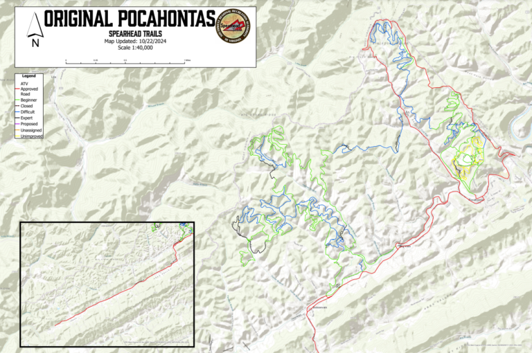
Trail Map
ALL PURPLE TRAILS ARE PROPOSED TRAILS (FUTURE TRAIL SYSTEMS) AND ARE NOT OPEN TO THE PUBLIC AT THIS TIME!
You must have a KML (Arcgis, Google Earth, Onyx) or GPX (Polaris Ride Command) file viewer to view maps after downloading the file.
Trail Photos


